About Contact

B.Arch Thesis · UAP · 2017

Metamorphosis:
Towards Transit-
Oriented Dhaka

DMRT Line-6 · Agargaon Metro Station · TOD Infrastructure · Urban Mobility

The title is precise, not poetic. Dhaka is a city mid-metamorphosis: not yet what it will become, no longer fully what it was. DMRT Line-6 cuts through Agargaon, and the city's first mass rapid transit line is not an addition to the urban fabric — it is a reorganisation of it. The thesis arrives at exactly this threshold.

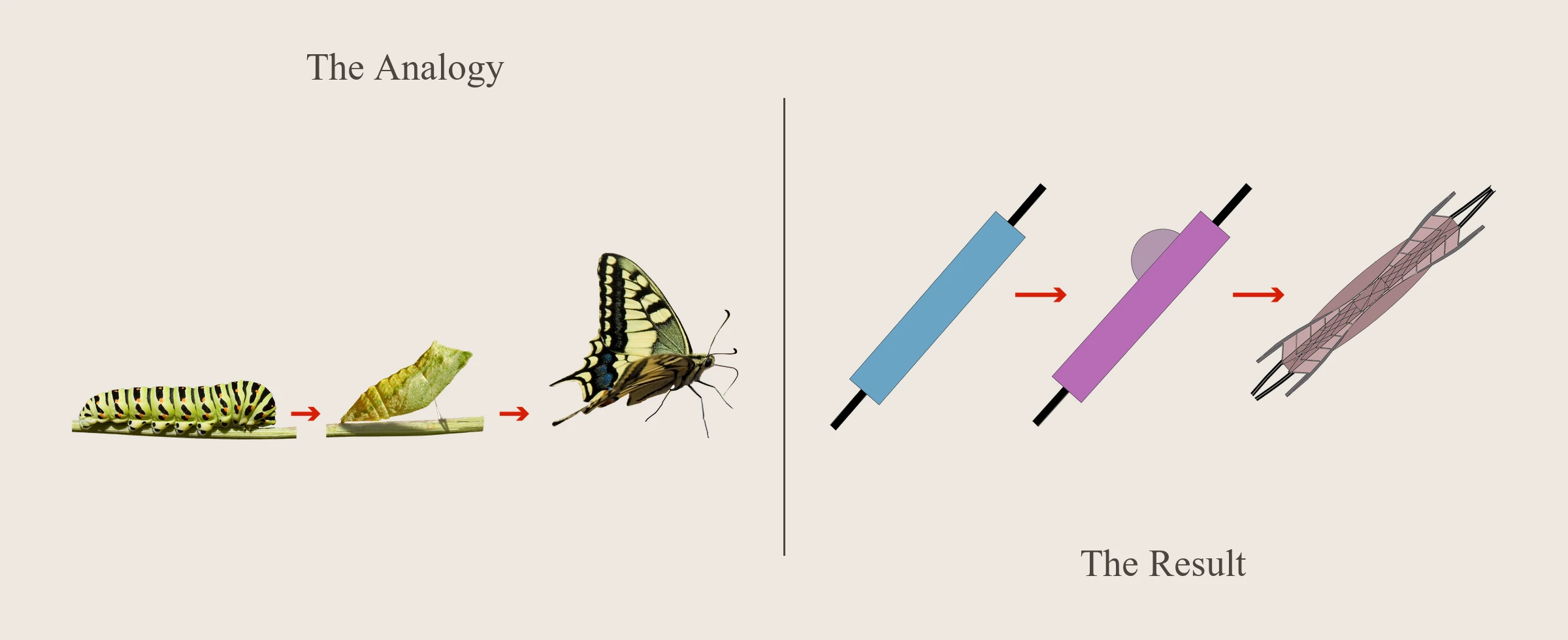
The formal premise is an analogy the thesis names "The Analogy": the caterpillar, the chrysalis, the butterfly. The existing transit node condition is the caterpillar: functional, linear, indifferent to its urban context. The design act is the chrysalis. The butterfly is a station that catalyses rather than merely serves: transit-oriented development above, below, and around the infrastructure, consolidating the bus interchange, activating the ground plane, and making the act of moving through the city a civic rather than merely transactional experience.

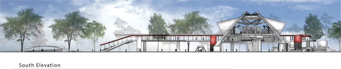
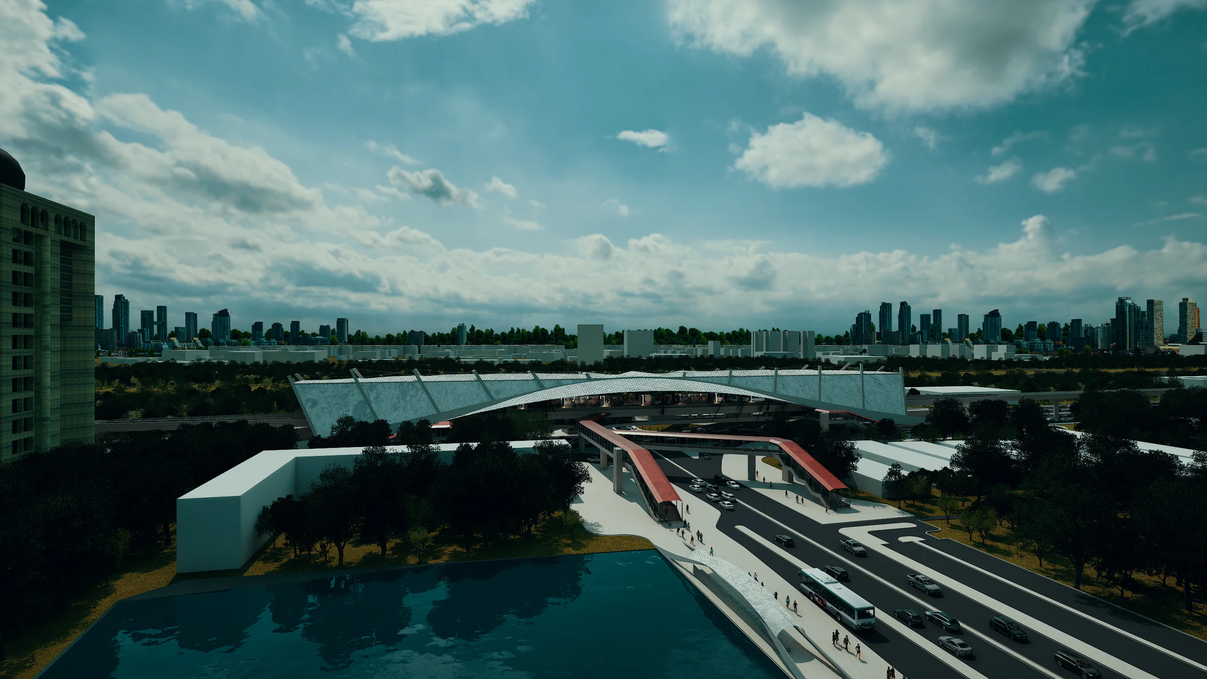
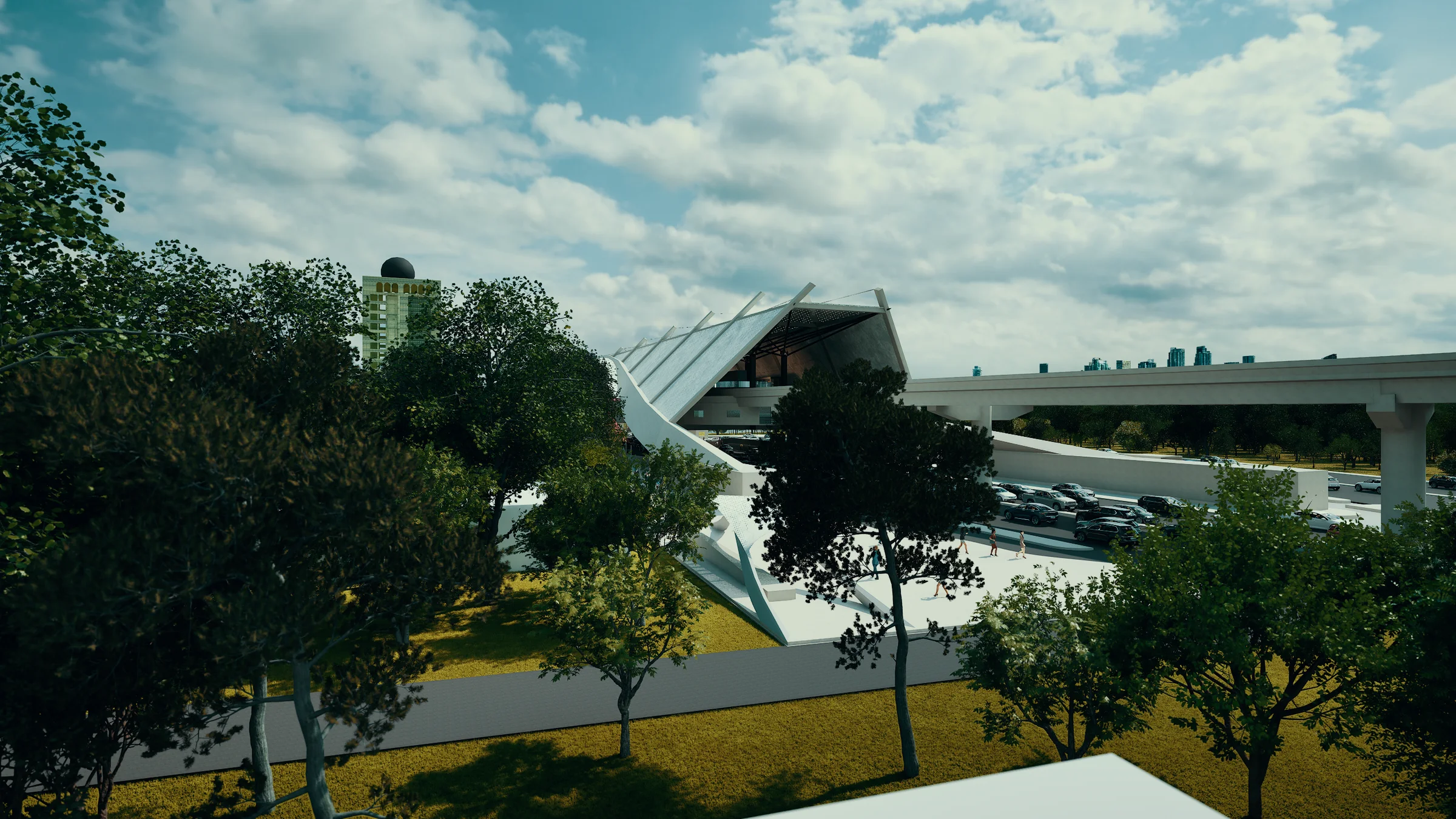
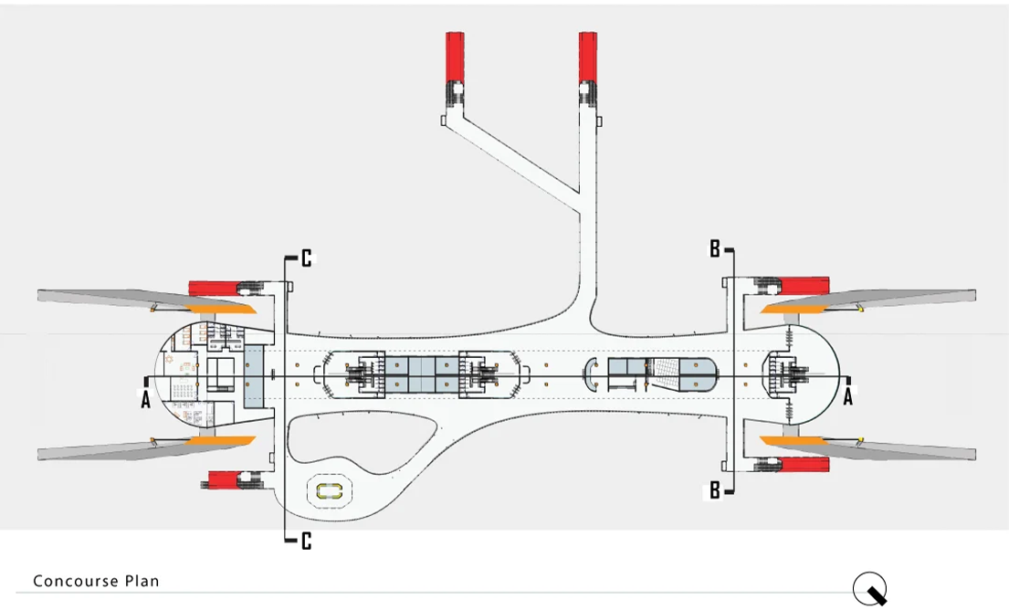
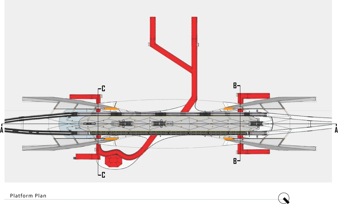
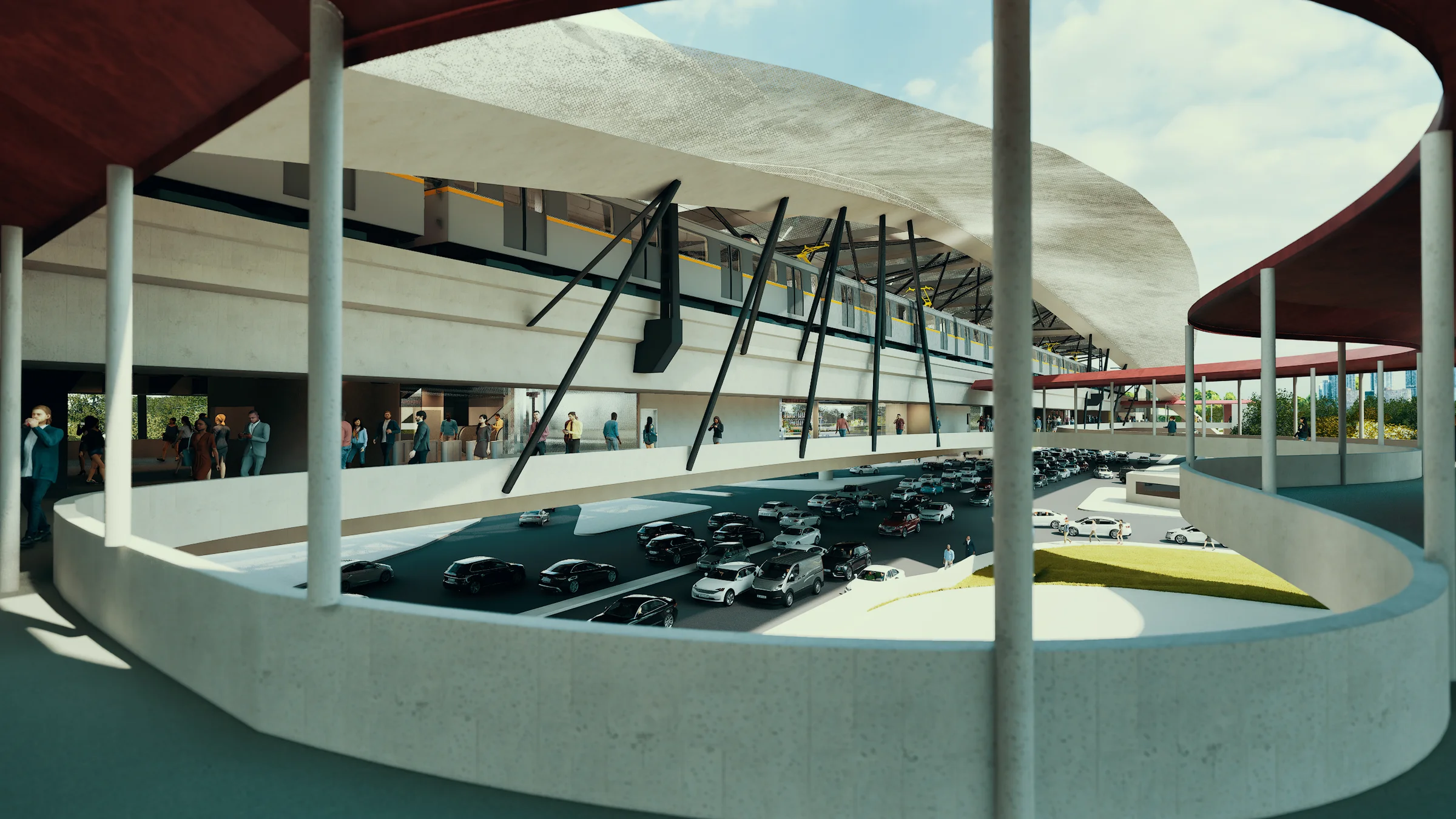
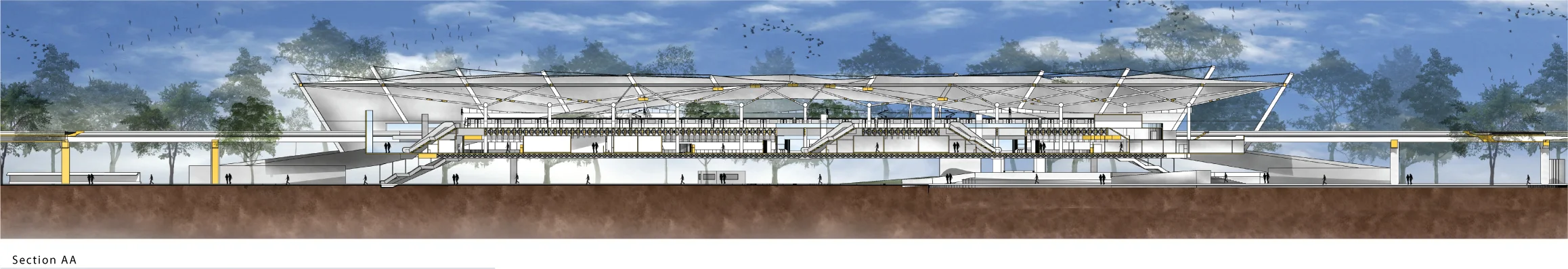
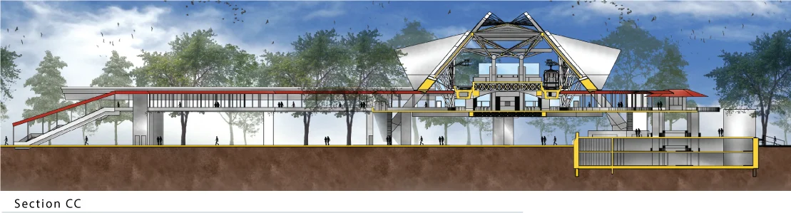
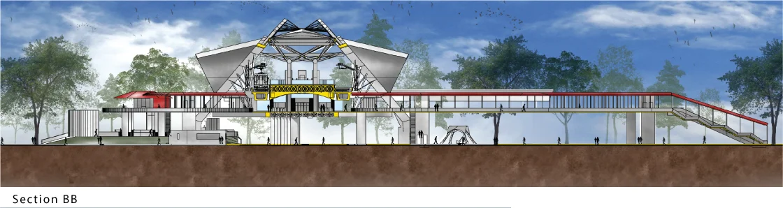
The station operates across three strata. Underground: parking and MEP. The ground plane: a continuous surface consolidating bus interchange, pedestrian priority, and mixed-use retail into a single activated threshold. The elevated body: concourse, platform, and the folded steel canopy that spans the whole as a single civic gesture. The red circulation spine — visible from street level, from aerial, from inside — traces the path from pavement to platform as one continuous legible movement.

Programme Metro Station
Transit-Oriented Development
Location DMRT Line-6, Agargaon
Dhaka, Bangladesh
Supervisor Muhtadin Iqbal
B.Arch (BUET)
Institution University of Asia Pacific
Dhaka, Bangladesh
Degree B.Arch (Architecture)
Year 2017

The Analogy

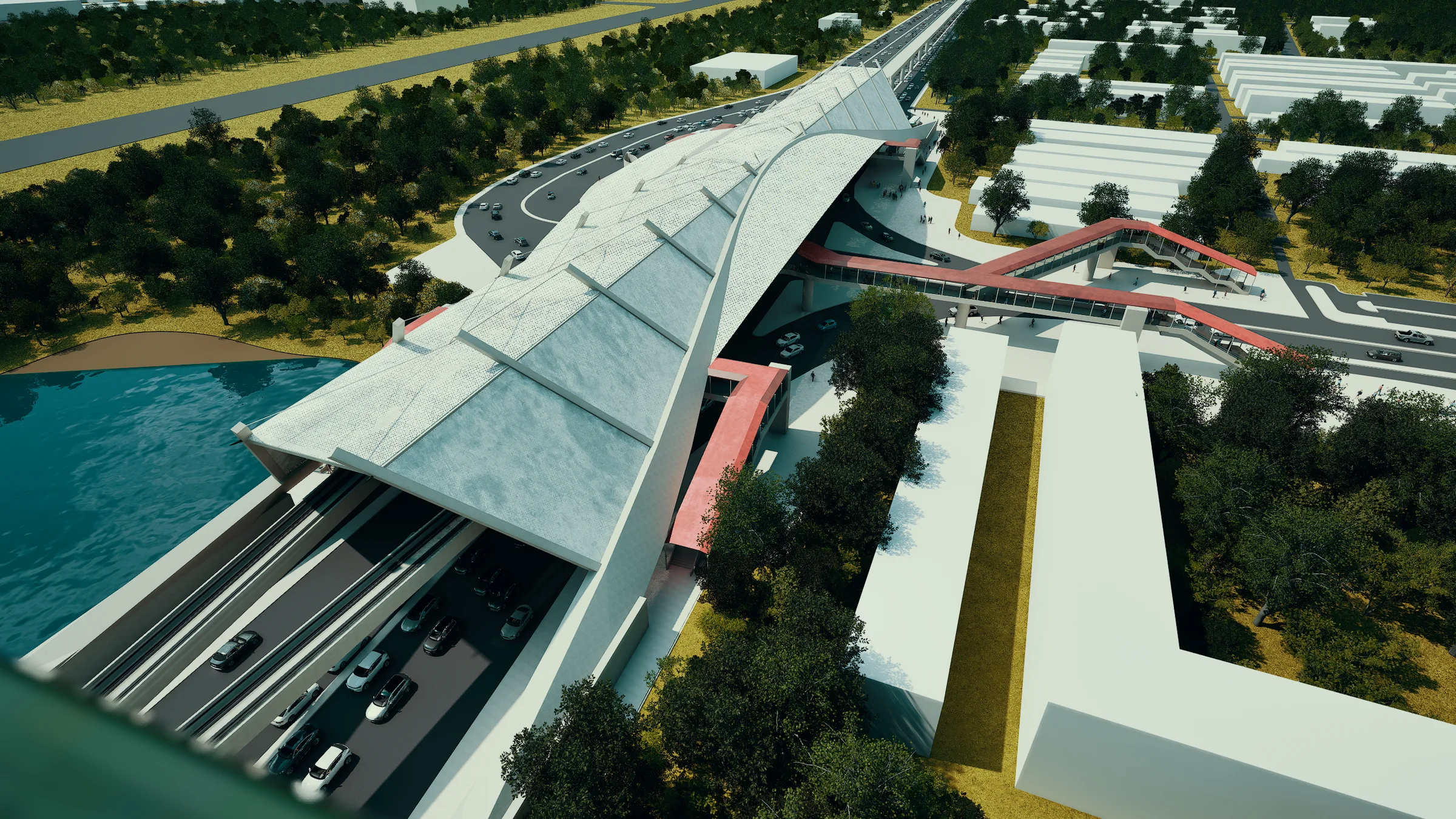
The caterpillar is the station as pure infrastructure: a bar across a track, serviceable, inert, urban only by accident. The chrysalis is the moment of design intervention, where the programme is held in suspension and reorganised. The butterfly is what emerges: the same transit node, now a city-making instrument, its form registering the energy of mass movement and releasing it into the streets around it. The plan reads this transformation directly. Two rounded station-head buildings anchor each end of the platform spine; the whole, seen from above, resolves into the butterfly's silhouette.

Parti diagram: the analogy of caterpillar, chrysalis and butterfly mapped onto the station's transformation from a linear bar to the final butterfly-silhouette plan

Site and Context

Agargaon sits at the administrative edge of Dhaka: government ministry blocks, a technical institute, two ornamental lakes, and the Mirpur Road cutting north. The site plan reads as an intermodal node embedded into this fabric. The station body aligns with the metro track; the bus interchange extends east; pedestrian flows are redistributed across a reworked ground surface that takes the intersection apart and reassembles it around the logic of transit.

Site plan: station in Agargaon urban context, two ornamental lakes flanking the site, metro line running north-south, bus interchange to the east
Ground-level circulation plan: pedestrian priority surface, vehicle drop-off zones, bus interchange bays, access ramps to the elevated concourse
Wide aerial render: the full station form spanning the Agargaon interchange, the ornamental lakes flanking east and west, the butterfly canopy and red circulation spine, Dhaka skyline beyond 
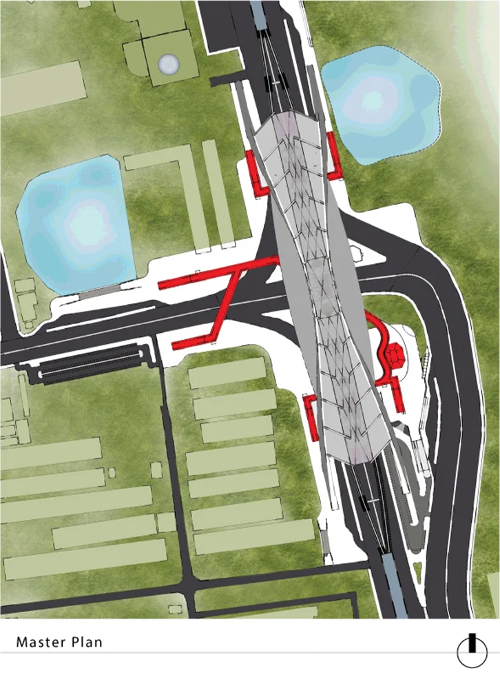
Aerial · Site Context
Close aerial render: the station roof and folded canopy structure from directly above, the ornamental lake to the west, the red ramp tracing the elevated pedestrian path from ground to platform Aerial · Station and Lake
Station head from ground level: the angular folded roof of the station head seen from the approach road, mature trees framing the form, the elevated metro viaduct visible to the right 
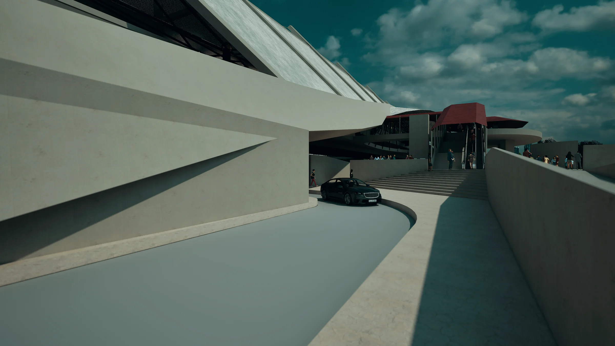
Station Head · Ground Approach
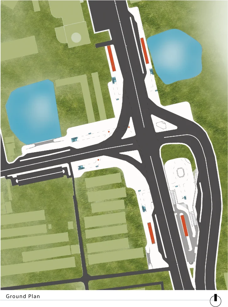
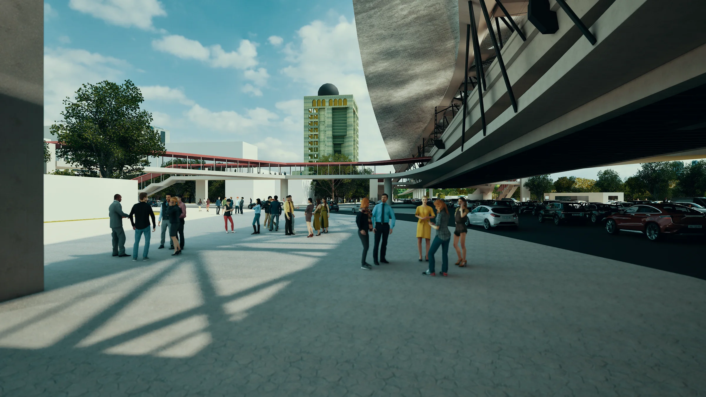
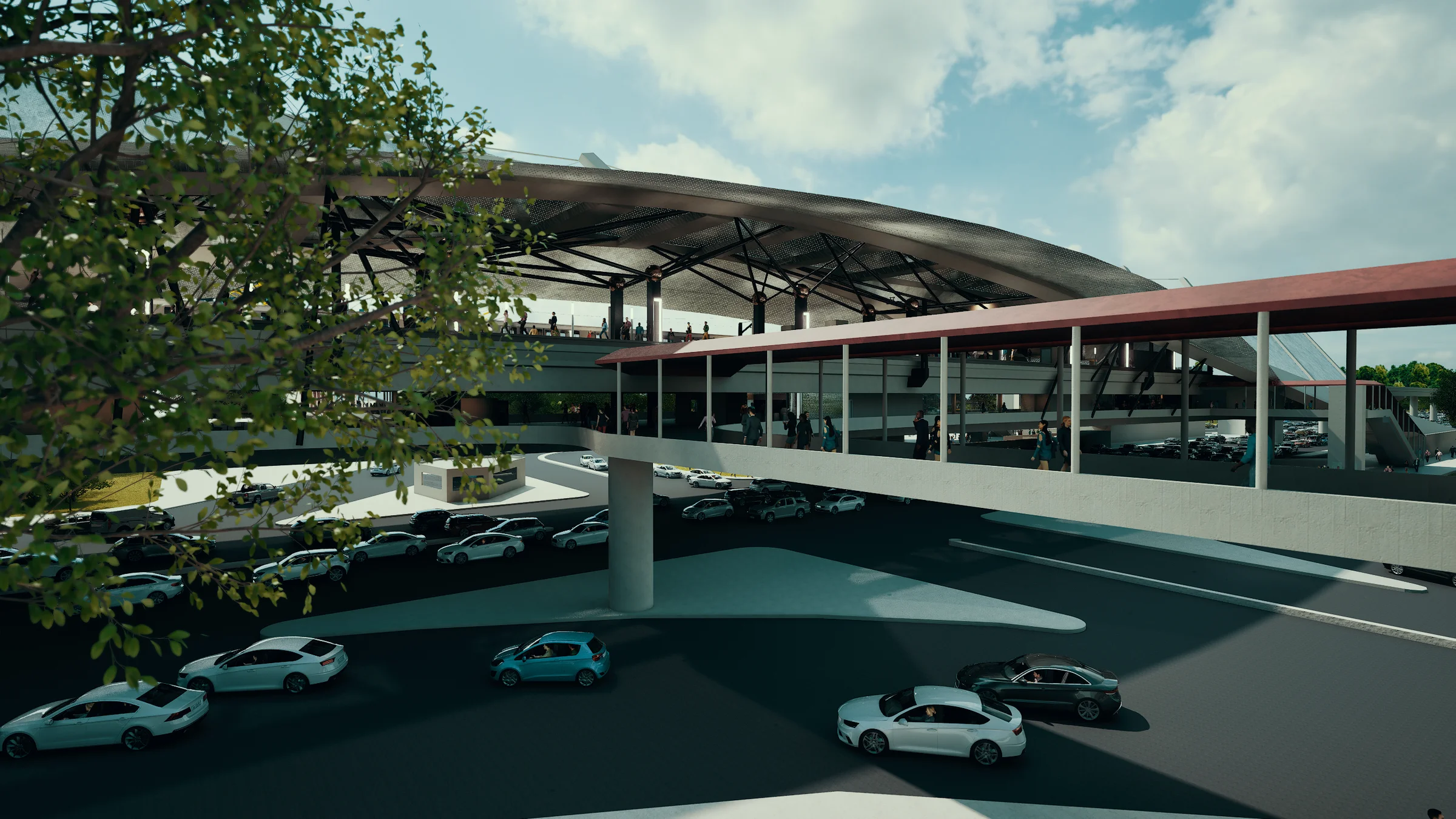
The Ground Plane

The ground is where the transformation is most legible. The station does not sit above the city and ignore it; it reorganises the surface around itself. Bus bays are pulled in from the surrounding streets and consolidated beneath the concourse canopy. Pedestrian flows are separated from vehicle movement and given a continuous shaded surface. TOD retail — food court, pharmacy, departmental store, florist, cyber café, gallery — lines the station perimeter, activating the edges at grade. The folded canopy overhead registers as civic infrastructure from within a car, from the pavement, and from the arriving bus.

Concourse level plan: the full butterfly form with the two rounded station-head buildings at each end, platform spine at centre, section cut references A, B and C marked
Structural plan: the same butterfly form with the red circulation spine highlighted, structural grid and canopy column positions shown
Ground-level plaza: commuters gathering beneath the curved soffit of the station head, the red ramp structure rising behind, the activated ground surface between interchange and TOD retail Ground Plaza · TOD Activation
Exterior approach: a car navigating beneath the angular concrete underside of the station, the red canopy and entry stair visible beyond, the station head facade rising at the end of the approach Vehicle Approach · Station Entry
Street-level exterior: the concourse canopy and TOD volume from the roadside, parking consolidated beneath the elevated platform, the full span of the folded roof visible Street Elevation · TOD Context

Interior Circulation

From street level to platform the journey is continuous and spatial rather than merely functional. The station head buildings at each end of the platform spine contain the programme that makes the station more than transit: retail, gallery, entertainment, accommodation. Between them, the concourse is a wide open hall with the red ramp system and escalators as the primary spatial event, routing commuters upward through a sequence of voids and light.

Station head plan detail: one of the two rounded programme buildings at the end of the platform spine, showing interior layout of retail, entertainment and civic uses
Station head interior: the concourse hall within the station-head building, floor-to-ceiling glazing opening directly onto the elevated roadway and Dhaka skyline, commuters descending toward the ground level 
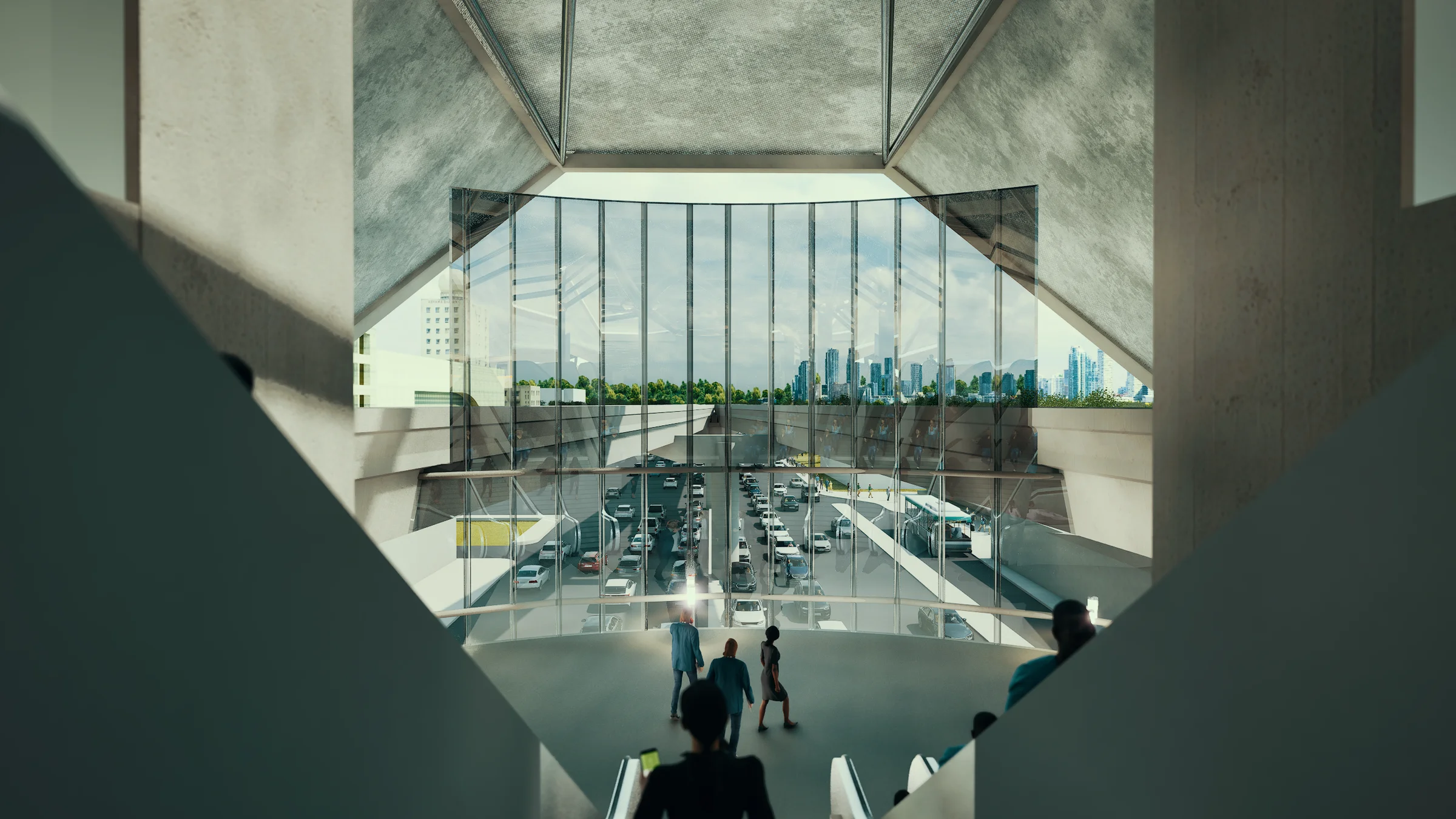
Station Head Interior · City View
Escalator hall: escalators and stairs rising through the station, the ornate lattice steel truss balustrade overhead, warm light filtering through the truss structure from above 
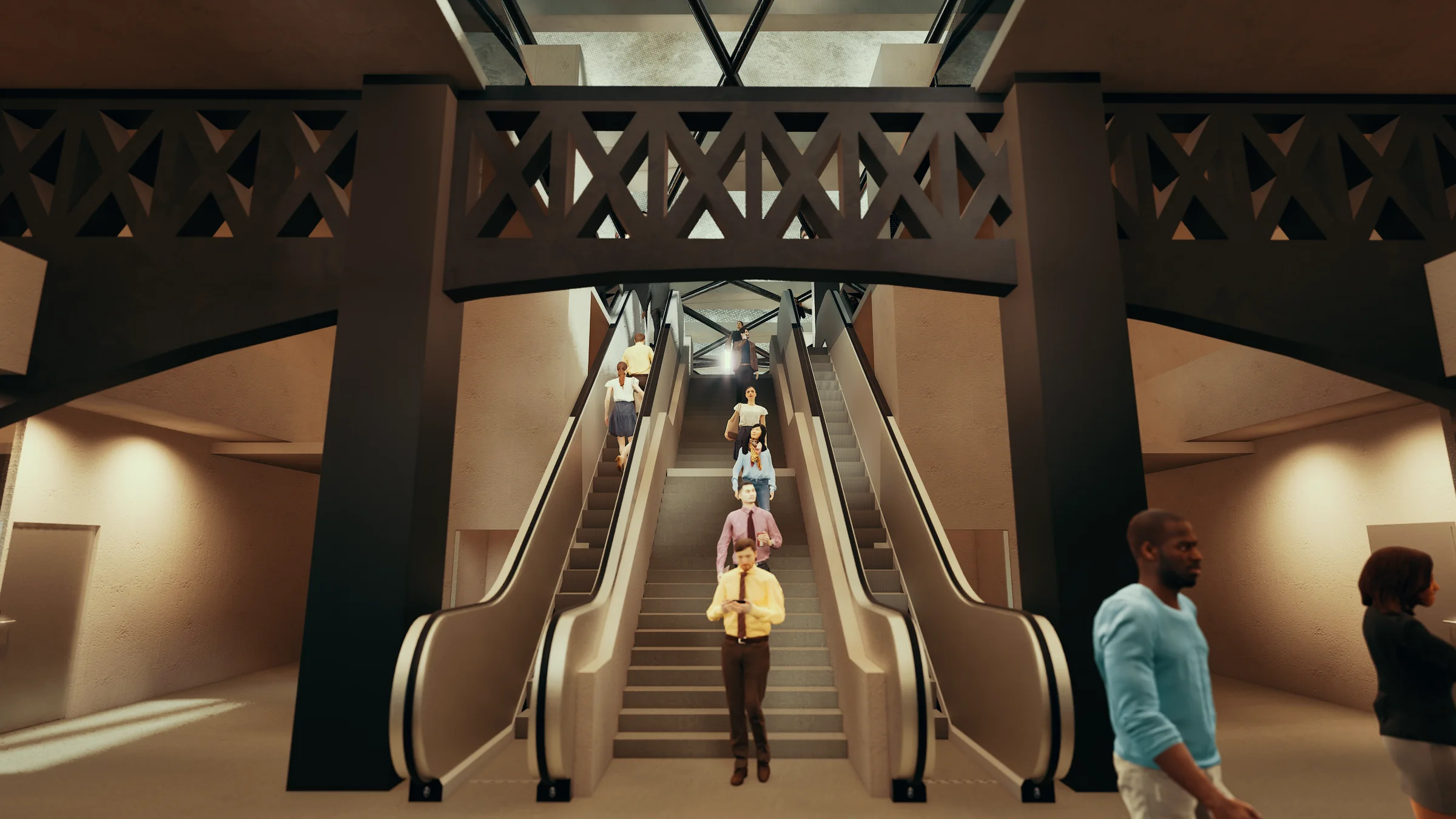
Escalator Hall · Vertical Circulation
Concourse level: commuters moving along the covered concourse beneath the dark timber-battened soffit, filtered light falling through the structural bays, the far station head visible at the end of the hall 
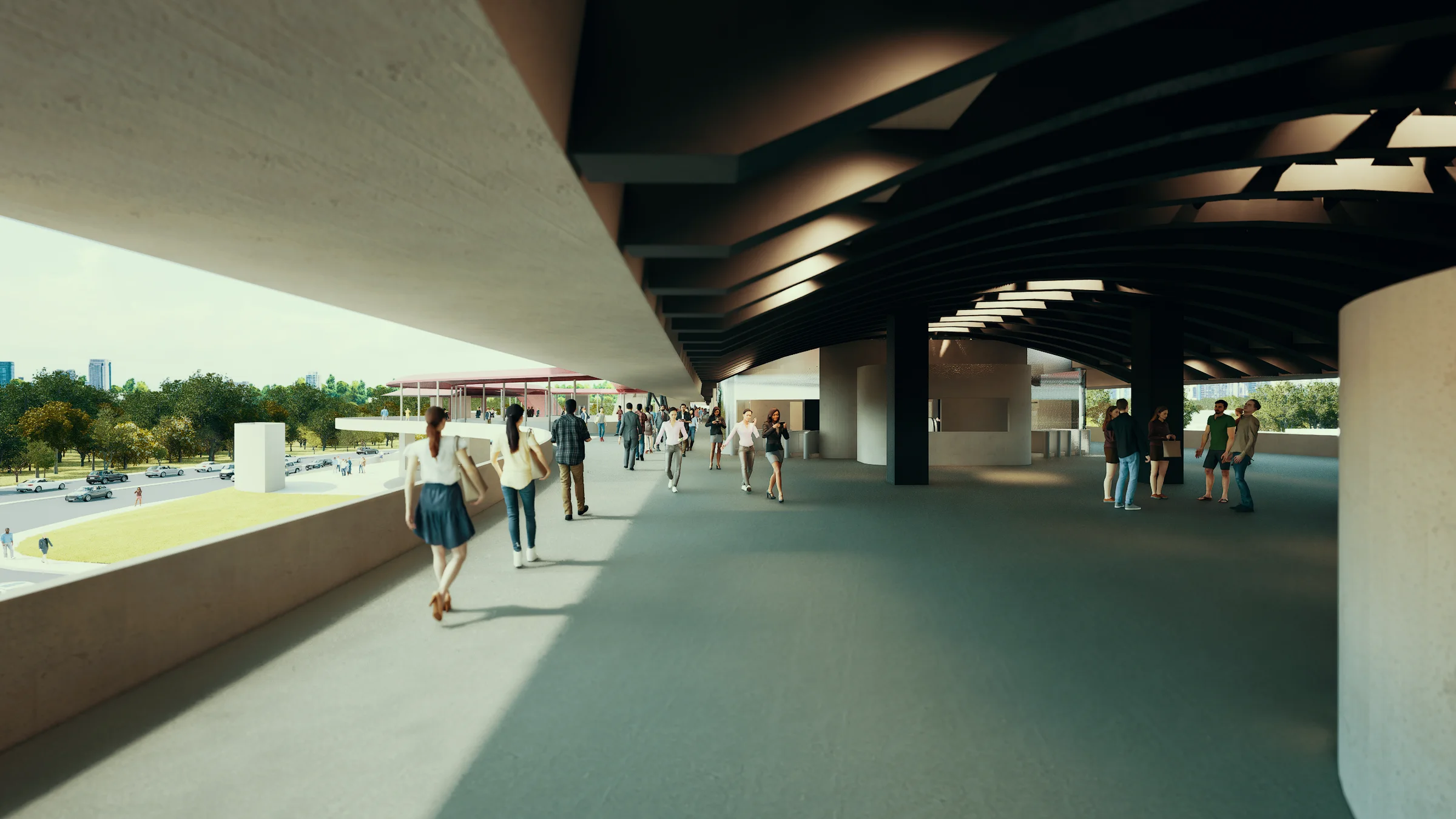
Concourse · Covered Hall
Concourse ticket hall: the fare gate and turnstile entry at the concourse level, ticket booths to the side, commuters passing through into the paid zone, columns and dark canopy soffit framing the threshold Concourse · Ticket Hall and Fare Gates
Foot-over bridge connection: the elevated pedestrian bridge linking the concourse to the surrounding urban fabric, the curved concrete underside of the station canopy overhead, the station head and red ramp visible at the far end 
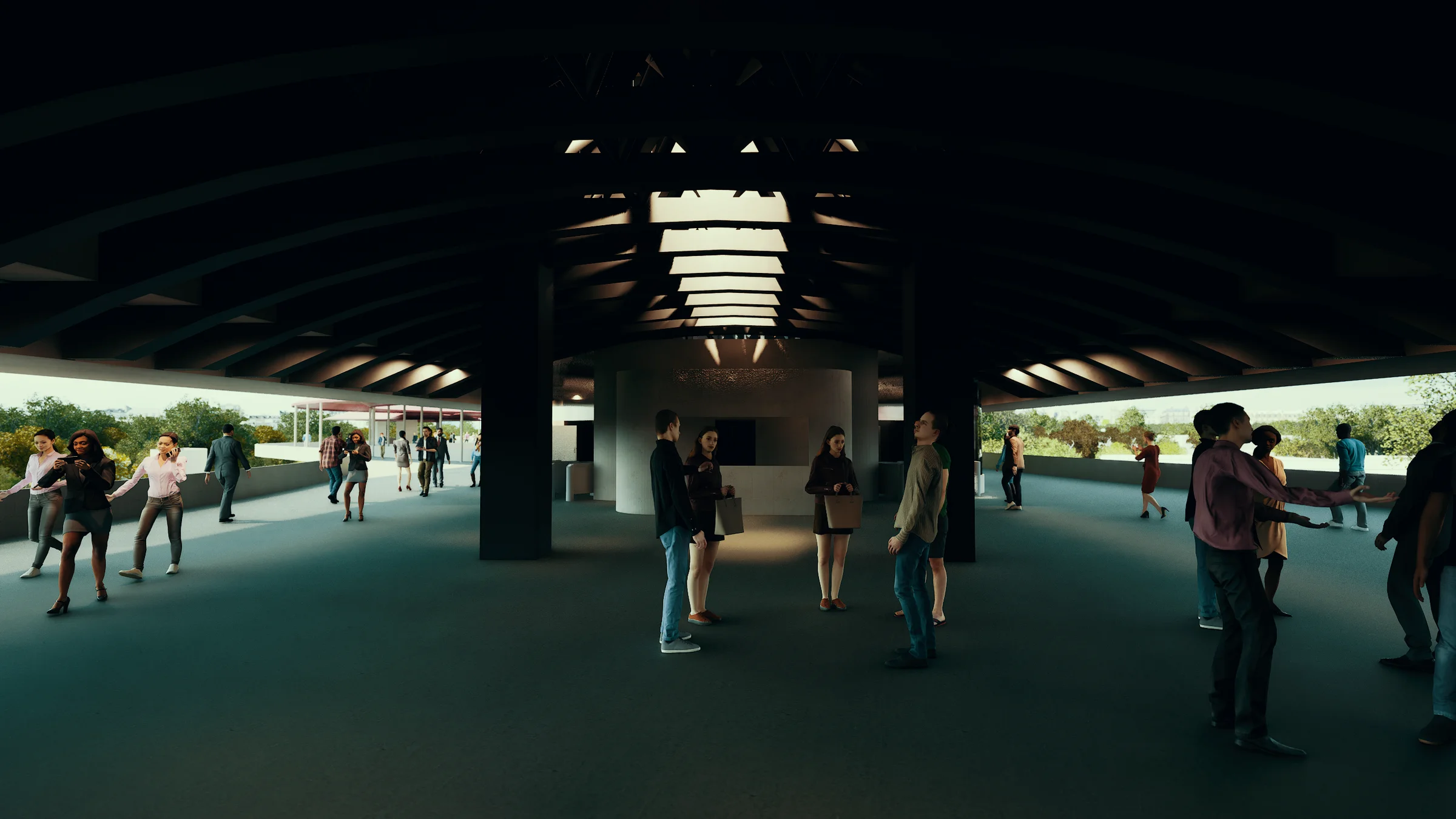
Foot-Over Bridge · Concourse Connection
Underground parking levels: the concrete multi-level stairwell descending through the station plinth, natural light filtering from above through the stair void, parking floors visible on each side 
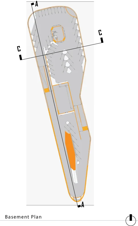
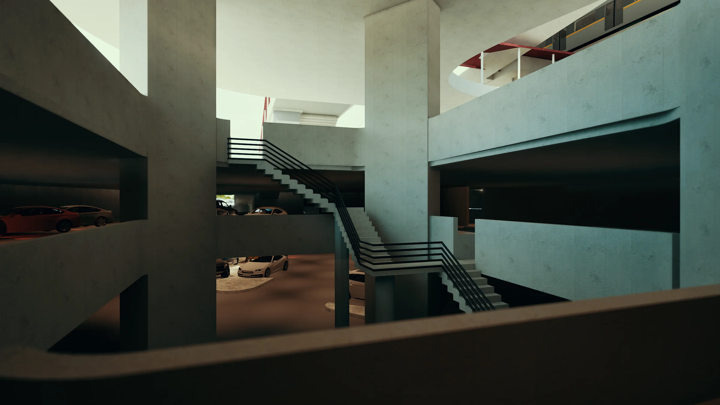
Underground Levels · Parking Plinth

Platform

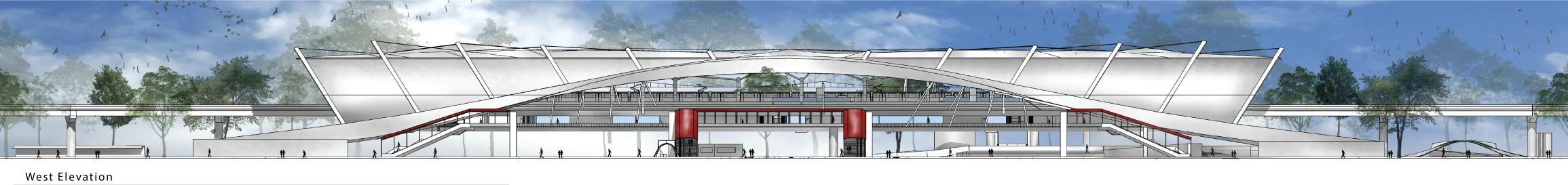
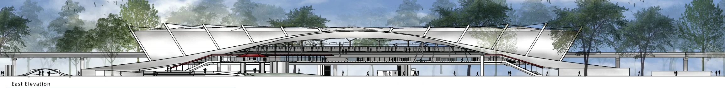
The platform is the terminus of the civic sequence. The folded steel truss structure overhead resolves the whole building into a single spatial room: open to light from both ends, the two tracks flanking the island platform, the city visible through the glass edges of the canopy. The structural logic that was readable as silhouette from the street becomes, from the platform, an inhabited ceiling.

Platform level: commuters alongside the train at the island platform edge, the copper-toned tubular steel truss structure overhead, the city visible through the open ends of the canopy 
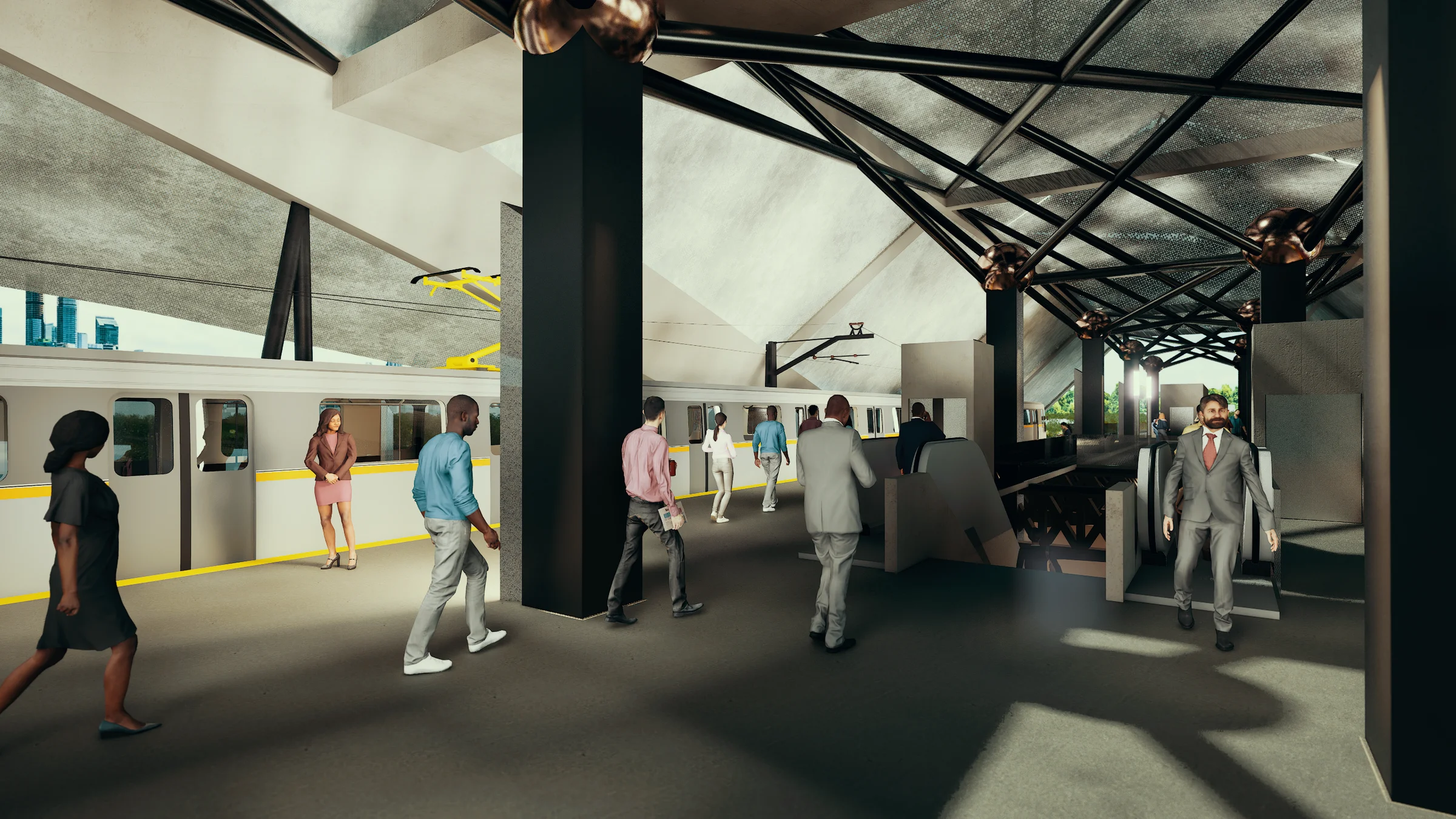
Platform · Train at Station
Platform spine looking west: the full length of the island platform beneath the diagonal steel truss roof, trains on both tracks, yellow safety line, Dhaka skyline at the far end 
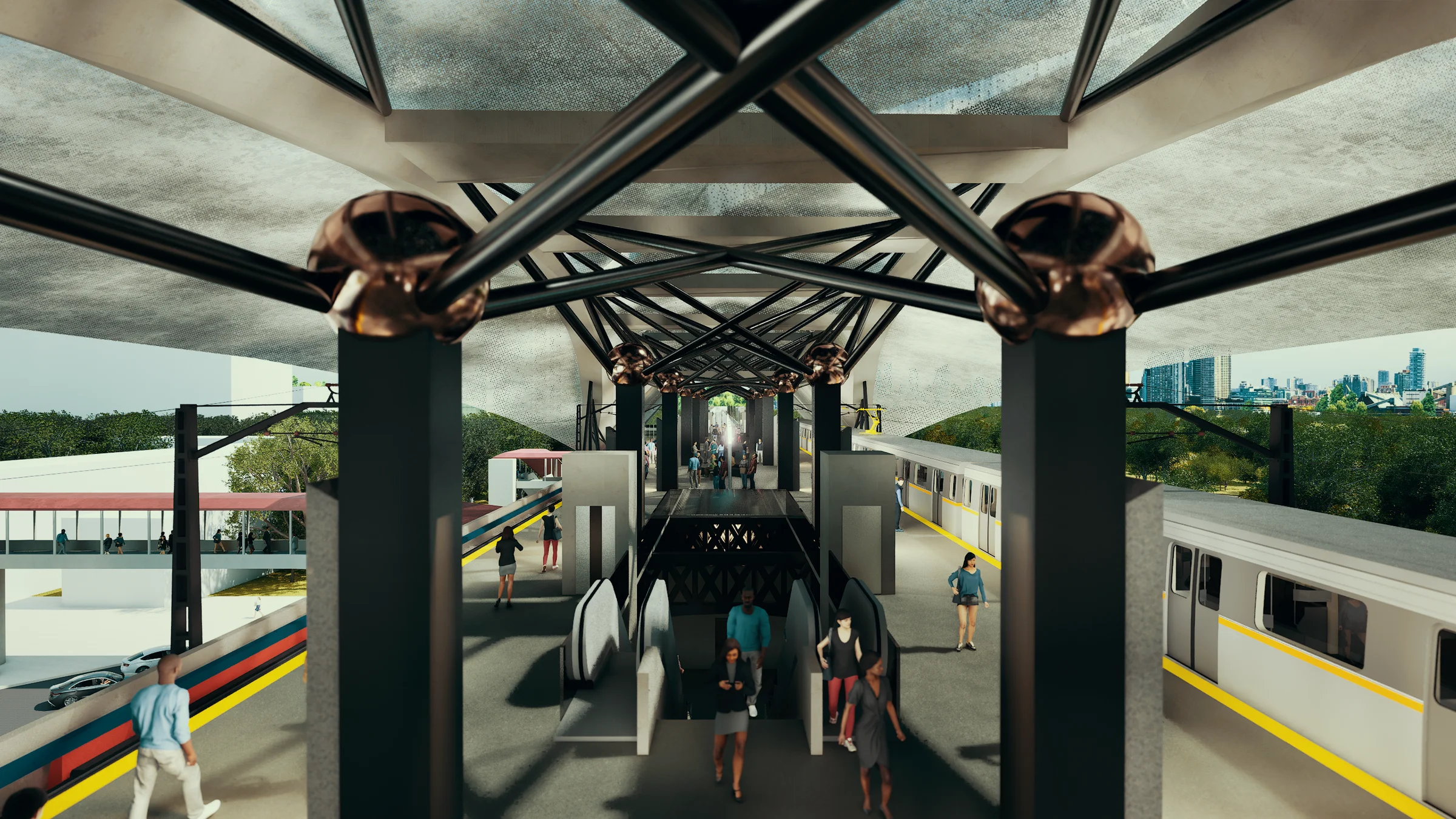
Platform · Island Platform

Sections

Section A-A: full longitudinal section through the station, showing underground parking at base, ground-level interchange, concourse, platform, and the folded steel canopy spanning the full length
Section B-B: transverse section through the station body, revealing the full height from underground to canopy peak, platform level at centre, structural trusses above
Section C-C: transverse section through the station head building, showing the programme stacking and the relationship between the station head and the platform spine

Elevations

West elevation rendered: the station building with the folded metallic roof and red canopy band, the concourse level glazing, trees and pedestrians at grade
West elevation: the sweeping canopy form spanning the full platform length, the red concourse band visible, station head buildings at each end
East elevation: matching the west in canopy profile, the bus interchange and ground-level activation visible at the base, Dhaka context implied beyond

Theoretical Framework

Peter Calthorpe
The Next American Metropolis: Ecology, Community, and the American Dream, Princeton Architectural Press, 1993 (via Ian Carlton, 2009): Calthorpe codified Transit-Oriented Development as a mixed-use community that encourages people to live near transit services and decrease their dependence on driving. He saw it as a neo-traditional guide to sustainable community design — not merely a planning instrument but a social vision bold enough to promise the redefining of the American Dream. The station is not the destination; the community organised around it is. Every programme decision in this thesis begins from that inversion: the metro station as city-making, not merely transit.
Ian Carlton
Histories of Transit-Oriented Development: Perspectives on the Development of the TOD Concept, UC Berkeley Institute of Urban and Regional Development, Working Paper 2009-02: Transport and the built environment are mutually dependent entities that have consistently pushed and pulled to create urban forms. Carlton's genealogy runs from Development-Oriented Transit through Auto-Oriented Transit and Transit-Supportive Development to TOD proper. Dhaka in 2017 is at the earliest arc of that sequence: transit enabling a city for the first time. This thesis proposes skipping two generations of urban mistakes and arriving at full TOD before the car takes irreversible hold.
Network Rail
Station Design Principles, Document BLDG-SP80-002, 2015: The document opens with Vitruvius via Henry Wotton: firmness, commodity and delight. Twelve design principles follow, from safety and security through intermodal exchange and wayfinding to retail, social programme, and passenger experience. The last four are the satisfiers, achievable only once the eight essentials have been met. This station designs for all twelve simultaneously, treating delight not as an aesthetic supplement but as the structural consequence of getting the civic programme right: a station so fused with the life of the city that it ceases to be noticed as infrastructure.
JICA / Dhaka Transport Coordination Board
Preparatory Survey on Dhaka Urban Transport Network Development Project Phase 2, Japan International Cooperation Agency / Katahira & Engineers International, January 2011: The Dhaka Metropolitan Area had a population of 9.15 million in 2009, a city that relied overwhelmingly on road traffic, with buses, automobiles and rickshaws sharing lanes without segregation or priority. The JICA study identified MRT Line 6 as the highest priority project from seven proposed mass transit routes, and forecast passenger demand rising from 249,000 persons per day at opening to 505,000 by 2025. Agargaon is the third node of Stage 1. This thesis designs that node.
United Nations DESA
World Urbanization Prospects: The 2014 Revision, UN Department of Economic and Social Affairs, Population Division, New York, 2015: In 2014, 54 percent of the world's population lived in cities; by 2050 the projection is 66 percent. The fastest urbanization is concentrated in Asia and Africa, precisely in the megacities where transit infrastructure has not kept pace with population growth. The thesis positions the Agargaon station not as a local infrastructure problem but as a response to a planetary condition: the city as the primary form of human settlement, and transit as the circulatory system without which the form collapses under its own density.
City of Winnipeg / PB PlaceMaking Group
Transit-Oriented Development Handbook, 2011: TOD is moderate to higher density compact mixed-use development, located within an easy five to ten minute walk (approximately 400m to 800m) of a major transit stop. TOD households are twice as likely not to own a car, and a single TOD station can increase ridership by 20 to 40 percent. Each station area can provide a sense of place by creating a unique character and identity that enables citizens to have a personal connection and experience with the place in their daily lives. The station at Agargaon is designed to do exactly this for Dhaka: not a point on a line but a place with a life of its own.
Bithica At the Hearth of the Real